


Ortholes - Canabols

bonnetchristian
User
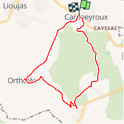

Length
8.4 km

Max alt
633 m

Uphill gradient
121 m
Km-Effort
10 km

Min alt
559 m

Downhill gradient
120 m
Boucle
Yes
Creation date :
2014-12-10 00:00:00.0
Updated on :
2014-12-10 00:00:00.0
--
Difficulty : Unknown

FREE GPS app for hiking
 SityTrail
IGN / Geographical institutes
SityTrail Plus
The world is yours!
About
Trail Walking of 8.4 km to be discovered at Occitania, Aveyron, La Loubière. This trail is proposed by bonnetchristian.
Description
A pied ou en VTT, l'Aveyron dans ses multiples facettes
Positioning
Country:
France
Region :
Occitania
Department/Province :
Aveyron
Municipality :
La Loubière
Location:
Unknown
Start:(Dec)
Start:(UTM)
472355 ; 4916740 (31T) N.
Comments